Newsletter Issue 2
June 2014

Newsletter | Issue 2 | June 2014
» View this newsletter as a PDF
Welcome to Edition #2 of the CGI Newsletter. In this edition we welcome three new CGI councillors, and we kick off efforts to coordinate standards for 3D geological models.
Table of Contents
New Members of CGI Council
Three new members have been elected to CGI Council to replace the recently retired Richard Hughes and to fill two other vacancies. We welcome Kombada Mhopjeni (Geological Survey of Namibia), Zhang Minghua (China Geological Survey), and Santiago Munoz (Geological Survey of the Dominican Republic).
CGI Working Group News

The Geoscience Terminology Working Group, in collaboration with the EarthResourceML Working Group recently approved the adoption of 18 new vocabularies to support delivery of mineral occurrence and mine data using the EarthResourceML data transfer standard. The vocabularies have been developed in collaboration with the European Union’s Minerals Intelligence Network for Europe (Minerals4EU), so that Minerals4EU vocabularies use either exactly the same terms or have mappings to CGI terminology. The vocabularies are to be published soon through the CGI’s vocabulary service.
3D Geological Data Models — a call for participants in a review of 3D standards
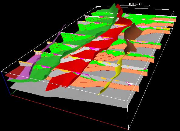
By nature, geological information is 3D (or even 4D). To date, CGI efforts to support geological data interoperability have focused on exchange of geological map and borehole information with GeoSciML and EarthResourceML, using GML as the underlying spatial data engine. With the growing demand for exchanging 3D geological models in many domains (eg, oil and gas, mining, groundwater, design of infrastructure), there is a clear need for standardizing the exchange of 3D models independently of the data format used by the modeling software.
There is currently no accepted generic exchange model for 3D geological models, although there have been some attempts in different organizations or projects. The CGI Council considers it a priority for the Commission to
- review the current situation in the delivery of 3D geological models, and
- propose a strategy for identifying or developing an agreed standard possibly in partnership with other standardization bodies.
We are now calling for volunteers to participate in an ad-hoc group to be setup in CGI on this topic. If you are interested, please email the CGI Chair, Francois Robida.
GeoSciML News
![]()
The joint OGC/CGI GeoSciML Standards Working Group (SWG) has recently held two teleconference meetings – one of them as part of the quarterly OGC Technical Committee meeting in Washington DC. Steve Richard provided a summary of his recent work to document the use cases needed for development of the GeoSciML version 4 standard. The working group will gather together in Tucson, USA from June 29 to July 3 for its annual face-to-face meeting. This will be held in conjunction with similar meetings of the EarthResourceML and Geoscience Terminology working groups, and the OneGeology Technical working group.
A new user guide for GeoSciML data providers has also just been published by the British Geological Survey as part of their contribution to the EU INSPIRE initiative. The new user guide and other GeoSciML resources can be found on the GeoSciML website.
News from China
A 1:1 million scale geological map of China has recently been released by the China Geological Survey as a contribution of China to the OneGeology initiative. The 1:1M geological map data cover most of the land areas of China and is now available as a OGC Web Map Service (WMS). Map layers include bedrock lithology, lithostratigraphy and major faults. For further information, contact your CGI councillor from China, Zhang Minghua.
News from Africa
![]()
The 25th Colloquium of African Geology will be held in conjunction with the 3rd Congress of the Young Earth Scientists network (YES) in August 2014, in Dar es Salaam, Tanzania. During the conference, the GIRAF Network and the Southern and Eastern African Mineral Centre (SEAMIC), is organising a session on geoscience information in Africa. Other conference participants are expected to include the Geological Society of Africa (GSAf), The African Association of Women Geologists (AAWG), OneGeology, AEGOS, and UNECA.
The geoscience information session will include presentations and discussions on the building of spatial data infrastructure in Africa, regional geoinformation initiatives; interoperability and standards; and best practices in delivery, dissemination and exploitation of geoscience information. Participants are encouraged to submit abstracts on their solutions and experiences of managing and delivering geoscience information to underpin public policy-making, investment, research and education. Contact the CGI secretary general and GIRAF coordinator Kristine Asch.
Featured Project
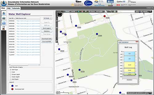
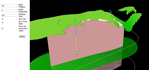
The Canadian Groundwater Information Network (GIN) connects water well databases from British Columbia, Alberta, Saskatche-wan, Manitoba, Ontario, Québec, Nova-Scotia, and Yukon, and some key aquifer information from Natural Resources Canada.
The GIN data analysis portal enables users to view water wells and supporting hydrogeological maps in 2D and 3D, and to display and download geological well logs and water information from wells. The GIN makes use of the GroundwaterML data transfer standard for water wells and GeoSciML to deliver the downhole geological information.
Upcoming Events
The FOSS4G PDX 2014 conference will be held in Portland, Oregon, USA from 8–13 September. The annual FOSS4G conference is the largest global gathering focused on open source geospatial software. FOSS4G brings together developers, users, decision-makers and observers from a broad spectrum of organizations and fields of operation. Through six days of workshops, presentations, discussions, and cooperation, FOSS4G participants create effective and relevant geospatial products, standards, and protocols.
CGI hopes to sponsor a competition at this conference for developers to design and build an application that displays innovative use of interoperable geoscience data, such as web map and web feature services and standard geoscience vocabularies.
More Upcoming Events…
![]()
CGI members Robert Tomas, Marco Komac and Carlo Cippoloni will be presenting at the 8th INSPIRE Conference in Aalborg Denmark, 16–20 June 2014. They will talk on aspects of European and global geoscience interoperability. The European Union’s INSPIRE interoperability initiative has been both a great user of, and valued contributor to the development of, the CGI’s geological data standards - GeoSciML and EarthResourceML.
The AfricaGEO 2014 Conference & Exhibition will be held at Cape Town International Convention Centre (CTICC) from 1–3 July 2014. The conference aims at facilitating interaction, discussion, collaboration and capacity building amongst the participants. It will provide a platform to share the latest developments in the industry of surveying and geo-information (including remote sensing and aerial imagery) and the pressing issue of sustainable development.
FOSS4G-Europe, Europe’s largest ever event on free geospatial and location-based software will be held at Jacobs University in Bremen, Germany from 15–17 July, 2014. Also at this conference, the winners of the Academic NASA Worldwind Europe Challenge will present their innovative apps to the public. Among the keynote speakers are Jeff McKenna, OSGeo President, and Patrick Hogan from NASA. Students are actively engaged through a summer school on the theme, with presenters from Europe and USA.
The Modern Information Technologies in the Earth Sciences (ITES 2014) conference is coming up in Kamchatka, Russia, from 8–13 September 2014. Topics that the conference will cover include networking for data acquisition, remote sensing, open access to data, virtual research media and laboratories, modelling, cloud technologies, and spatial data infrastructure.
Meet Your CGI Councillors

Mike Frame is Chief of Scientific Data Integration and Visualization, at the U.S. Geological Survey (USGS). He is responsible for geospatial, informatics, and technology research and oversight within USGS. Mike has also served as the chief system architect for various national and international distributed biological networks and as a Principle Investigator on several US National Science Foundation projects.
Prior to joining USGS, Mike earned a bachelors degree in Electrical and Computer Engineering and a masters in Industrial Engineering/Information Systems from the University of Tennessee. Mike was the Deputy Director of Information Systems Development with the U.S. Department of Energy (DoE), where he was responsible for the design and implementation of a DoE-wide research and development system. This effort earned a National Partnership for Reinventing Government Hammer Award in 1998.
Mike is currently a USA representative on several international efforts relating to biological and geo-informatics and serves on several Advisory Boards. Contact Mike.
Join Us on LinkedIn

We invite all CGI members to join our new LinkedIn group. The group provides a forum for CGI and LinkedIn members to connect with other geoscience professionals, post news of upcoming events, ask questions and discuss your issues.