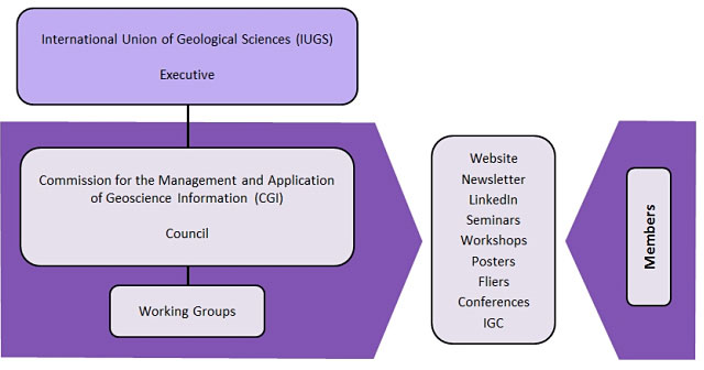
IUGS Commission for the Management and Application of Geoscience Information (CGI)

Explore our website for resources about data sharing, standards, and best practice in geoscience information management.

Join Now

CGI-IUGS

CGI-IUGS

CGI Secretariat

IUGS

About Us

CGI’s mission

To foster the interoperability and exchange of geoscience information, by active community leadership, collaboration, education, and the development and promotion of geoscience information standards and best practice.

CGI’s vision

  • that geoscience information can be exchanged, understood, and used without limitation,
  • that geoscience information can be readily integrated with standards-based information from other knowledge domains,
  • that geoscience information is semantically rich and structured to enable seamless interaction in all environments,
  • that global education about the management, modelling, exchange, and use of geoscience information enables its best possible application,
  • for the benefit of all society.

CGI Structure

CGI Structure

Our Partners

OneGeology

OneGeology’s aim is to create dynamic digital geological map data for the world. It is an international initiative of the geological surveys of the world who are working together to achieve an ambitious and exciting venture. The OneGeology organisation endorses and uses the GeoSciML data transfer standard and has worked closely with CGI in providing a platform for the use and promotion of CGI data standards.

Open Geospatial Consortium (OGC)

CGI is a strong supporter of the open standards framework established by OGC. CGI and OGC cooperate under a Memorandum of Understanding signed in 2013 under which the future development of GeoSciML will be undertaken in an OGC Standards Working Group (SWG).

Infrastructure for Spatial information in the European Community (INSPIRE)

The INSPIRE directive have chosen CGI standards - GeoSciML and EarthResourceML - as the mandated European data transfer standards for geological and mineral resources information. The technical working groups of the INSPIRE directive have cooperated with CGI in the development of data standards and geoscience vocabularies.

US Geoscience Information Network (USGIN)

USGIN is an operational federated information-sharing framework that helps individuals and agencies develop scalable, interoperable, web-accessible data-sharing networks. USGIN participates in the development of standards, practices, and protocols through ESIP, CGI and the OGC, and deploys systems using these to exchange geoscientific data over the Internet using free-and-open-source software.

CGI Council

Chair

Avatar

Harvey Thorleifson

Professor, University of Minnesota

Secretary General

Avatar

Dr Zhang Minghua

Director of Geoinformation and Engineering, Development Research Center, China Geological Survey

Treasurer

Avatar

Mark Rattenbury

Programme Leader, Nationally Significant Databases and Collections

Member

Avatar

Michael Sexton

Custodian, Mineral Deposits and Resources Database, Geoscience Australia

Avatar

Christelle Loiselet

Deputy head, Digital Department for Geosciences

Avatar

Edward Lewis

Geologist (Standards Lead)

Avatar

Jasna Šinigoj

Head of Geological Information Centre

Avatar

Kazuhiro Miyazaki

Deputy Director, Geology and Geoinformation Research Institute, Geological Survey of Japan

Avatar

Lesego P. Peter

Director of Information Delivery

Avatar

Mauricio Pavan Silva

Executive Coordinator at the Department of Geology of the Geological Survey of Brazil

Avatar

Mickaël Beaufils

Data Architect

Website Admin

Avatar

Edward Lewis

Geologist (Standards Lead)

News

*

Newsletter Issue 9

Welcome to Edition #9 of the CGI Newsletter. In this edition we report on the progress of the CGI Working Groups and the recent meetings of CGI members.

Meetings on the Status and Future of Global Geoscience Information Standards

CGI in partnership with IUGS’s Deep-time Digital Earth Project are hosting in-person meetings in Suzhou, China, 7-10 November 2023, on the Status and Future of Global Geoscience Information Standards.

Newsletter Issue 8

Welcome to Edition #8 of the CGI Newsletter. In this edition we report on the progress of the CGI Working Groups and the recent meetings of CGI members.

Geoscience Standards Training for DDE

Free 3 day training event on open standards applicable to the geoscience community

Newsletter Issue 7

Welcome to Edition #7 of the CGI Newsletter. In this edition we report on the progress of the CGI Working Groups and the recent meetings of CGI members.

Newsletter Issue 6

Welcome to Edition #6 of the CGI Newsletter. In this edition we report on the progress of the CGI Working Groups and the recent meetings of CGI members.

Election of Council 2020 - 2024

The Council was elected in 2020 for the term 2020-2024. The newly elected Council members are widely distributed across many of the continents. The planned annual face to face Council meeting in Delhi, India at the 36th IGC was canceled due to the COVID-19 pandemic.

CGI council elections

Nominations for CGI Council for 2020–24 are open. Any CGI member can nominate to serve on the council to help organise CGI’s standards programme and the outreach activities of the CGI.

CGI Award for Young Earth Scientists at the 36th IGC

CGI sponsors an award to assist early career scientists to present at conferences such as the IGC

36th International Geological Congress

Abstracts are invited to the special symposium Advances in geoscience data sharing and processing (Theme 45.10) at the 36th International Geological Congress (IGC). The symposium will highlight new techniques, standards, and algorithms for managing, delivering, visualising and analysing geoscience data both globally and regionally, including ‘big’ data.

New EarthResourceML-Lite v2.0.1

a data model and schema for simple map services (e.g. WMS and WFS Simple Features).

IUGS Deep-time Digital Earth program

IUGS President Qiuming Cheng announcing the DDE program at the opening of the DDE Forum. CGI is a founding partner in the new IUGS big science program, the Deep-time Digital Earth (DDE).

Recent CGI Meetings

Members of the EarthResourceML Working group met at IGME (the Spanish Geological Survey) in Madrid in May. L-R: Wang Yongzhi, Jouni Vuollo (chair), Mark Rattenbury, Ollie Raymond, Katarzyna Sadlowska, and Zhang Minghua.

Newsletter Issue 5

Welcome to Edition #5 of the CGI Newsletter. In this edition we report on the progress of the CGI Working Groups and the recent meetings of CGI members.

Newsletter Issue 4

Welcome to Edition #4 of the CGI Newsletter. In this edition we provide a look back at 2016 and a taste of what is to come in 2017.

2016 IUGS Science Excellence Award in Geoscience Information

Dr Stephen Richard Interdisciplinary Earth Data Alliance Lamont-Doherty Earth Observatory, Columbia University, New York, USA (previously Senior Geologist and Head of Geoinformatics, Arizona Geological Survey, Tucson, USA) Award Citation Steve Richard has been a global leader in the field of geological informatics for many years, and is well known and respected by the entire community.

Newsletter Issue 3

Welcome to Edition #3 of the CGI Newsletter. In this edition we particularly highlight the achievements of CGI members honoured with international awards in 2014.

Newsletter Issue 2

Welcome to Edition #2 of the CGI Newsletter. In this edition we welcome three new CGI councillors, and we kick off efforts to coordinate standards for 3D geological models.

Newsletter Issue 1

Welcome to the new face of CGI. We will be posting out several newsletters each year to keep members up to date with the latest news and events in geoscience information. We hope you enjoy our new newsletter.

2012 IUGS Science Excellence Award in Geoscience Information

John Laxton British Geological Survey, UK John Laxton was the Chair of the CGI Interoperability Working Group from its inception in 2004 until it was replaced in 2012 by the current CGI working groups.

Working Groups

*

DDE Standards Task Group

A collaborative task group implementing geoscience information standards for IUGS’s flagship Deep-time Digital Earth Project

EarthResourceML

A CGI working group developing and publishing data standards for mineral resources and mining information

GeoSciML

A collaborative OGC-CGI working group for the GeoSciML geological data standard

OGC-CGI Geoscience Domain Working Group

connecting people to develop, improve and promote technologies for geoscience data description and sharing

Geoscience Terminology Working Group (GTWG)

A CGI working group developing and publishing multi-lingual geoscience vocabularies

Metadata

Although the CGI does not have any formal working group concerned with geoscience metadata it was felt that it could help geoscience organisations develop their metadata implementations by providing a forum for posting work and discussions.

GIRAF

Pan-African geoscience information knowledge network of Geological Surveys, universities and companies

Regional Working Groups

The CGI council recognises the potential need to institute working groups that will address the specialised technical or scientific needs of regions defined by culture, geography or politics and encourages the establishment of CGI Regional Working Groups (RWG).

Multilingual Thesaurus Working Group

The mission of the MLTWG was to enable the global exchange of geoscience information with the help of a common multilingual core vocabulary by developing and expanding the Multilingual Thesaurus of Geosciences.

Interoperability Working Group

The Interoperability Working Group was formed to develop data standards to facilitate the query and exchange of geological information between data providers for environmental, scientific, legal and social purposes.

Publications

Quickly discover relevant content by filtering publications.

DDE Geoscience Information Metadata Standard

This standard defines the information content and XML serialization for metadata descriptions of geoscience information resources supporting the DDE program. It provides information about the identification, quality,contents, spatial reference, lineage, and distribution of the data. This standard applies to the description ofgeoscience data resources including a variety of geoscientific disciplinary spatial and non-spatial data, toensure they are Findable, Accessible and with sufficient documentation to make them Reusable. The scope of DDE Geosciences Information metadata is defined to include the resource types listed in the resourceType codelist. See the ResourceTypeCode «CodeList» in Annex A. Conformance with this standard will ensurethat DDE metadata are i nteroperable, facilitating metadata searching, h arvesting and sharing.

Contact

Join CGI

Map of members, click to enlarge. There are currently over 340 CGI members from 77 countries

CGI is run on a voluntary basis by the CGI Council, a small group of people from geological organisations around the world.

CGI would like to have representatives in every country in the world and membership is open to all whose nations and organisations are part of International Union of Geological Sciences.

CGI welcomes membership applications from all whose nations and organisations are part of The International Union of Geological Sciences.

If you have any feedback, comments, or suggestions, please Contact Us.

Email Contact

General enquiries

Membership